Observations from the Transact Walk Along the Buckingham Canal
Uvakai Research Foundation led a transect walk on January 17th along the Buckingham canal as part of their study and research on the kovalam river basin . The team examined the 13kms stretch of buckingham canal, which drains the 300 sqkm of pallikaranai catchment in the kovalam basin at the kovalam backwaters. The walk started from where Okkiyam Maduvu joins the canal and further toward the Kovalam backwaters and ended in the muttukadu boat house. This blog focuses on reflections based on that observation.
Observation 1:
Varying Width of the Water Channel and Shrinking Floodplains
The B Canal width varies across different places and area of the flood plain also kept varying.
Below are our observations.
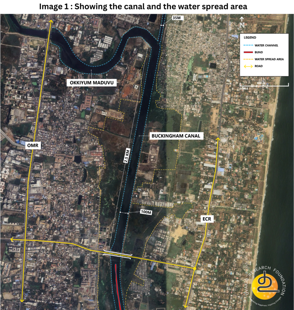
- Where Okkiyam maduvu joins B Canal, the water channel is 100 meters wide, with floodplains extending around 500 meters on either side.
- After Karunanidhi Salai Bridge, the canal bifurcates into two channels and the flood plain area starts to shrink.
- The eastern channel, identified as the Buckingham Canal, is 35 meters wide till Muttukadu boat house.
- The width of the western channel varies significantly along its course, ranging from 35 to 100 meters.
- Near Maritime University Campus, the combined width of both channels is close to 125 meters including the bund in between, without any floodplain on both sides.
- The university campus encroaches upon the western floodplain creating a bottle neck, obstructing the flow of water in that area.
- Near Semmanchery, the water channels widen and narrow intermittently. In this area, the floodplains are occupied by Jeppiar Salt Pvt Ltd (as mentioned in google maps).
- At Olympia Opaline Residential Development, floodplains widen to 300-400 meters, then shrink to 100 meters at the start of Muttukadu.
- From Muttukadu the floodplains expand again to 350 meters as the canal joins the Kovalam backwaters.
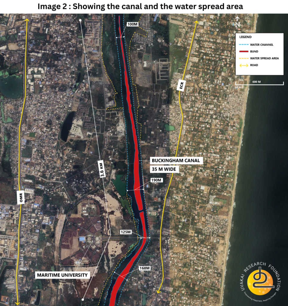
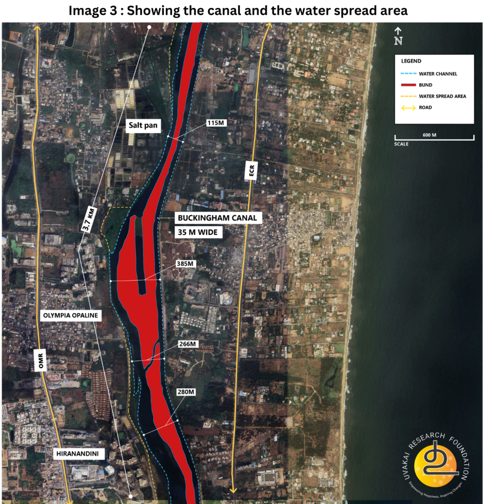
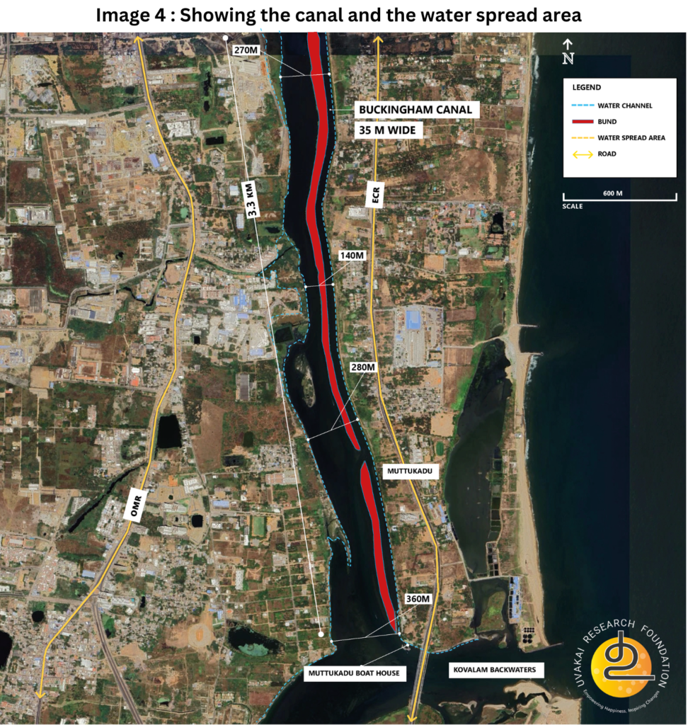
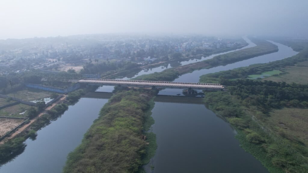
It is observed that the bund separating these two channels is indicative of incomplete dredging work. This suggests that the proposed dredging project in this section has either been abandoned or remains unfulfilled.
Retaining a uniform width of the canal is crucial during flooding. A consistent width will allow water to drain smoothly without any obstructions. Therefore, maintaining a 100-meter width along the entire 13 km stretch of the canal is essential.
Unfinished ₹123 Crore Inland Waterways Project (2014): A Call for Clarity and Action
The Inland Waterways Authority had sanctioned a ₹123.40 crore project to develop the South Buckingham Canal stretch from Sholinganallur to Kalpakkam (37 km) (PIB, GOI, Ministry of Shipping, 24 January 2014). Launched on January 24, 2014, by the Union Minister of Shipping, the project aimed to:
- Dredge and excavate the canal for navigation.
- Construct three terminals and navigational locks.
- Replace the existing bridge at Kelambakkam.
- Install navigational aids.
However, during our field survey, none of these components were visible, except for incomplete dredging. Initially, we assumed that the dredging was part of this project. But Google Maps evidence suggests that the dredging activity occurred around 2012—not in 2014—indicating that the ₹123 crore project never actually took off.
This raises critical questions:
- Why did the project not start?
- Who carried out the earlier dredging if it wasn’t part of the Inland Waterways project?
- Why was the dredging activity abandoned midway?
The government must urgently address whether the delay is due to administrative hurdles or funding constraints. If no adverse hydrological impacts are expected, simple interventions—such as widening the canal—should be prioritized in 2025 to prepare for the upcoming monsoon. Specifically, should the canal be dredged to a uniform width of 100 meters up to the Kovalam backwaters?
Restoring Water Flow and Capacity: A Strategic Approach to Flood Mitigation in Pallikaranai
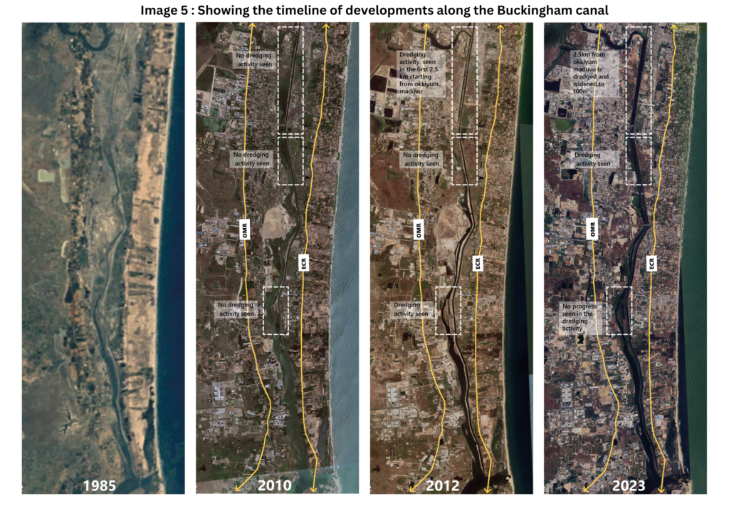
The area between Old Mahabalipuram Road (OMR) and East Coast Road (ECR) is naturally low-lying. Historically, water from the Pallikaranai marsh would spread across this region and drain gradually into the backwaters. However, urbanization has significantly reduced the water spread area, as shown in the Image 5 -Time line of developments along the Buckingham canal (Between Okkiyum maduvu to Kovalam backwaters) from 1985 – 2023. This shrinkage has drastically decreased the flood-carrying capacity of this region. The settlements have come all the way encroaching the flood plain, drastically changing the size of the water spread area along this stretch, obstructing the natural flow of water, there by flooding the neighbourhoods during excess flow during the monsoon.
Therefore, protecting the shrinking floodplain area by delineating its boundaries to prevent further encroachment is essential. At the same time, creating a uniform width of the floodplain by removing existing encroachments is very crucial.
Assessing the Impacts and Necessity of Dredging for Sustainable Flood Mitigation
While this intervention could enhance water flow and storage capacity, its ecological and hydrological impacts must be carefully studied. However, given that the ₹123 crore project initially aimed to dredge the entire area, these aspects were likely assessed and documented in the DPR. The Tamil Nadu Government should engage with the Inland Waterways Authority to review the existing DPR and take immediate measures to mitigate the impact of the upcoming monsoon.
The loss of natural water spread areas, crucial for flood mitigation and groundwater recharge, cannot be overlooked. A balanced approach—combining targeted dredging with the restoration and conservation of low-lying areas—is essential to effectively address flooding at its root.
Reflections and Call to Action
The transact walk highlights the need for a more comprehensive and integrated approach to managing the Buckingham Canal and its surrounding ecosystems. The incomplete dredging project underscores a lack of focus on holistic planning. Beyond dredging, addressing urbanization’s impact on natural drainage systems and prioritizing sustainable flood mitigation strategies are crucial steps forward.
It is imperative for stakeholders, including policymakers, urban planners, and local communities, to come together and reassess the priorities for this region. Without a coordinated effort, the challenges of flooding and ecological degradation will persist, affecting both the environment and the community.
