
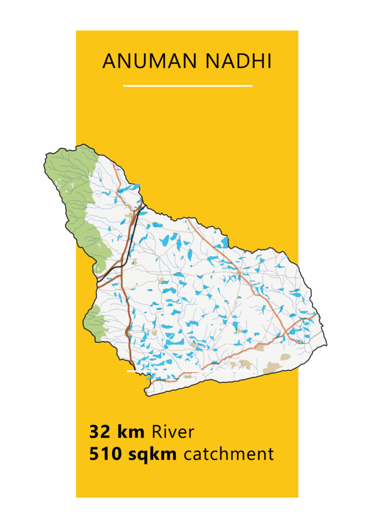
The Anuman River, also known as the Hanumannathi part of the Kodayar Basin, originates in Parivirisuriyan village in the Western Ghats and flows through 12 revenue villages for 32 kilometers before reaching the Gulf of Munnar near Perumanal, a small fisherman community village.
A collective effort led by the farmer’s association, youths, and dedicated villagers from 12 villages formed ‘Nam Anuman Nathi’ under the Societies Act to restore and maintain the river, transcending religious, caste, and political affiliations. The Rural Development Programme at Anna University (AURDP), led by the late Prof. G. Sakthinathan, provided crucial technical guidance.
The team conducted an FMB survey, utilized DGPS surveying, cleared encroachments, widened the river, and reinforced the bund. These achievements were made possible through collaborative efforts involving the district administration, Anna University, and the local community. In 2021, this collective effort resulted in the replenishment of all tanks linked to the Anuman River, with over 30 tanks refilled after three decades.
Further actions are necessary, including repairs to anicuts and surplus weirs, establishing riparian zones to mitigate floods, implementing strategies to prolong water flow, protecting against sand mining, and desilting tanks, and enhancing micro-irrigation techniques.
To ensure sustainable economic empowerment among farmers, the Anuman Nathi FED Farmer Producer Company has been established with support from NAFED and guidance from Viruthai Millets, the CBBO. Ongoing efforts invite interested parties to join this initiative by contacting us.
Dr. E. Vidhubala, the Founder Director of Uvakai, played a crucial role in facilitating the Anuman River restoration project. Currently, Uvakai aims to continue the unfinished work and ensure its long-term sustainability in this basin.
Anuman Nathi faces challenges related to water scarcity and drought management, requiring strategies for water conservation and the development of alternative water sources. Conversely, Pazhayaru deals with challenges associated with flood control and managing excess water, necessitating measures for flood mitigation and ensuring safety.
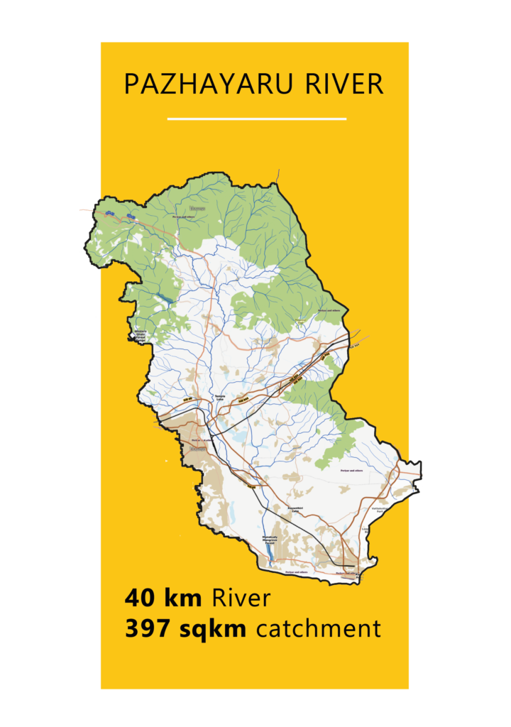
The Pazhayar River originates from the Northern slope of the Western Ghats at an altitude of 550 meters above Mean Sea Level (MSL). It flows for 35 kilometers, taking the name ‘Pazhayar River’ near Surulacode at an elevation of 55.85 meters MSL, and drains the Pazhayar river sub-basin before entering the Arabian Sea near Manakudy. The river spreads out like a lake for 7.5 kilometers near North Thamaraikulam before reaching the Manakudy estuary. With a catchment area of 397 square kilometers, it flows between the Vellimalai range on the right and the Western Ghats on the left. The Pazhayar river sub-basin is considered a safe zone for groundwater, with a surface water potential of 95.5 million cubic meters (MCM) and a groundwater potential of 117.09 MCM, as per the Environmental and Social Assessment Report (2017) of the IAMWARM Phase 2.
The Pazhayar River sub-basin had historically maintained an efficient water management system for centuries. However, negligence and inadequate resource allocation for maintenance in recent decades have placed this historically significant river under multiple stresses.
Natural and human-induced encroachments have resulted in a significant reduction in the river’s width, leading to frequent flooding episodes and substantial damage to crops in the basin. River bank breaches frequently occurred as a consequence of excessive water inflow from heavy rains, severely disrupting the daily lives of several villagers by inundating roads and causing widespread inconvenience. Poor solid waste management practices and pollutants from villages along the river have also caused further stress.
These challenges demanded immediate attention and timely intervention to protect the Pazhayar river and ensure its preservation for future generations.
A group of like-minded individuals from the Kanniyakumari district joined hands to address the challenges faced by the Pazhayar River, working in coordination with various technical, administrative, and community stakeholders.
As a preliminary step, a baseline situational analysis of the Pazhayar River in the Kanniyakumari district of Tamil Nadu was conducted. This study employed a multidisciplinary approach, integrating field surveys using FMB and DGPS technology, historical data analysis, and stakeholder interviews.
A field-level observation study was conducted in collaboration with the Constituent College of Anna University, Nagercoil, involving civil engineering students. The report was released by the District Collector at Anna University’s Nagercoil campus.
We invite you to be part of this initiative and join us in our efforts.
Efforts are ongoing as the district administration continues to remove encroachments and implement preventive measures to protect the river from pollution.
Following the successful restoration projects of Anuman Nathi and Pazhayar, the third river in line, Nambiyaru is now in focus. The commencement of Nambiyaru’s Phase I restoration is imminent, with active engagement from community stakeholders represented by Namadhu Nambiyaru.
The third river restoration project will be a comprehensive initiative focused on revitalizing the Nambiyaru River, which has suffered degradation from natural and human factors. The project will incorporate various surveys and analyses, including the FMB survey for precise boundary determination, DGPS technology for digital mapping and restoration planning, aerial surveys for detailed assessment, and situational analysis studies for a thorough understanding of current challenges. Anticipated benefits will include improved ecological health, disaster prevention, and enhanced water flow for tanks and communities. Implemented through a public-private partnership, the project will emphasize local engagement and technical expertise for sustainable restoration. It will also aim to activate water user associations for participatory irrigation management, adhering to the TNFMIS Act of 2000. Uvakai, in collaboration with Atree, proposes to provide technical support for undertaking the first phase of the river restoration project.
Phase I activities are budgeted at 60 lakhs, with increased participation from community stakeholders. We invite you to be part of this initiative and join us in our efforts to revitalize the Nambiyaru River.
About This Sub-Basin
This map shows all the major features and data layers of the sub-basin. You can zoom in to explore the flow, boundary, and surrounding villages. The visual is powered by Power BI and updated regularly.