Image Source: Knight Frank India
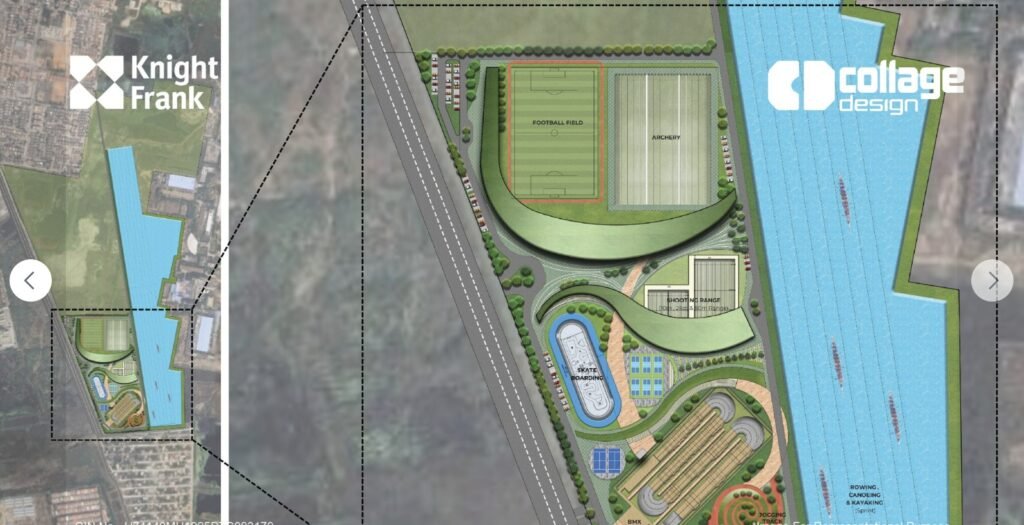
Image Source: Knight Frank India
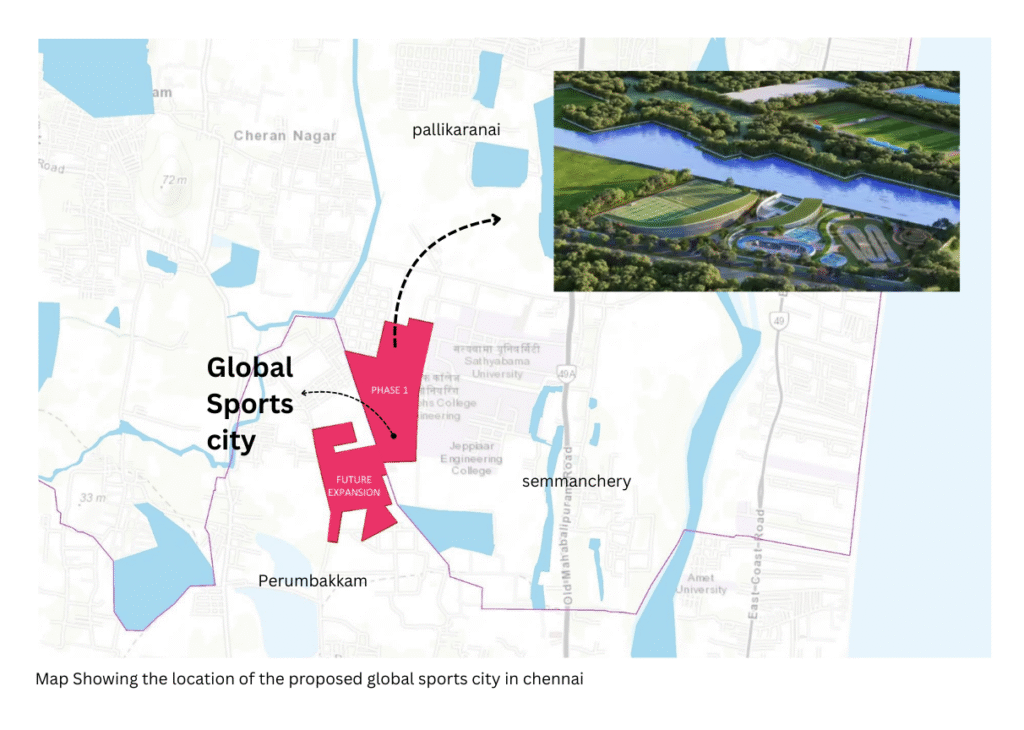
On 18 February 2026, the Hon’ble Chief Minister of Tamil Nadu laid the foundation stone for the proposed Global Sports Village at Perumbakkam, Chennai, at an estimated cost of ₹261 crores. The project seeks to establish world-class sporting infrastructure comparable to global standards and is envisioned as a premier training hub that will empower Tamil Nadu’s sporting community and enable athletes to compete confidently on international platforms. The foundation ceremony, attended by distinguished sportspersons nurtured by the State, reflected Tamil Nadu’s strong commitment to sporting excellence.
There is no doubt that such infrastructure is both necessary and timely. For many years, athletes and sporting communities have called for high-quality training facilities that can elevate performance and create a structured sports ecosystem. While the vision behind the Global Sports Village is commendable and forward-looking, this annexure respectfully places on record certain ecological, hydrological, and regulatory concerns regarding the presently proposed site location, which warrant careful consideration at this stage of implementation.
Project Location and Site Context
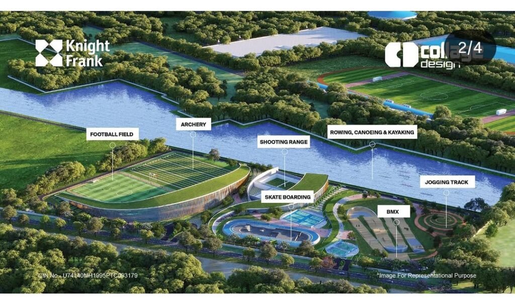
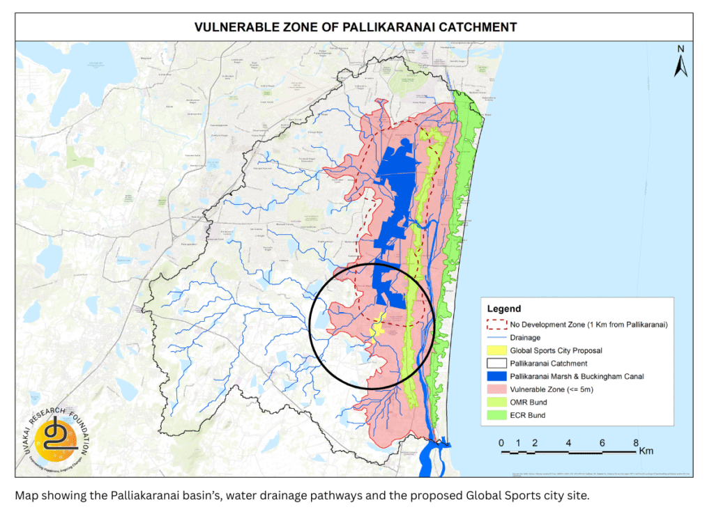
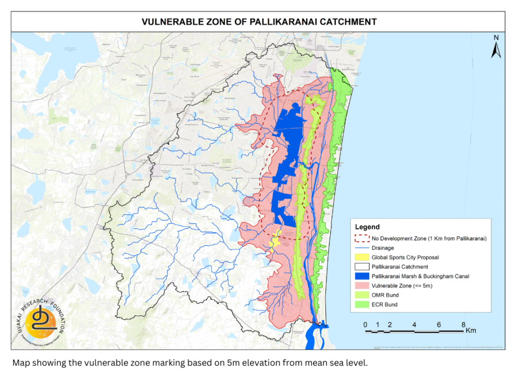
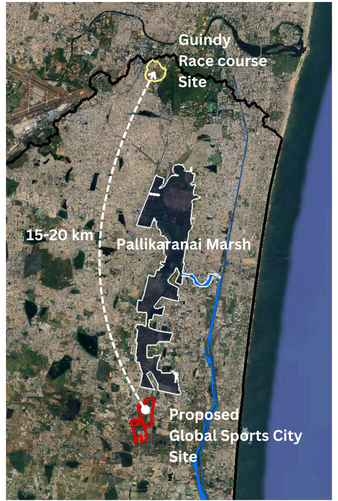
The proposed sports village spans 112.12 acres in Semmanchery village, within the Pallikaranai catchment region. A preliminary review using Google Maps imagery reveals visible water stagnation across parts of the site. In fact, portions of the land appear marked as waterlogged areas.
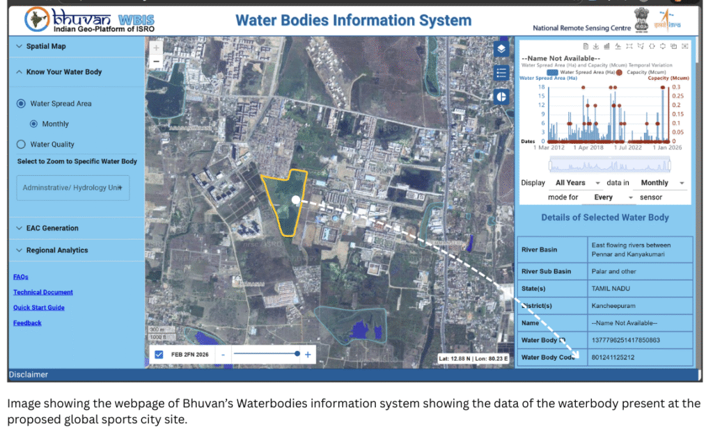
To verify this, the Bhuvan – Water Bodies Information System (WBIS) was examined. The satellite-based data clearly identifies a water body within the site boundary. The system assigns a unique identification number and has recorded storage and water spread data for nearly a decade (since 2015). This confirms that the area has historically functioned as a water-holding zone.
However, when cross-referenced with village revenue maps which was publsihed by Gov.of Tamilnadu in the 2005, the site locations show revenue divisions with survey numbers starting from 353 to 422 and there is no official categorization as water body. But the maps released in 1905 identifies this region a puromboke land as an extension of the Pallikaranai marsh system. Over time, gradual encroachments and regularization processes appear to have altered its present-day classification, but we could see water stagnant throughout the year. This discrepancy between satellite hydrological evidence and revenue records raises important questions.
Hydrological Analysis: A Critical Drainage Path
A stream-order analysis of the Pallikaranai basin provides deeper insight.
The southern and south-western portions of the basin naturally drain toward the northern Pallikaranai marsh. The proposed sports village site lies directly within this drainage pathway.
This implies that runoff from over 250 upstream water bodies converges and drains through or near this proposed site.
In hydrological terms, this makes the location:
A natural flood transit zone
A runoff convergence corridor
A high water-stagnation risk area during monsoons
Any obstruction, elevation alteration, or built-up intensification in such zones can disrupt basin-scale hydrology and exacerbate flood vulnerability.
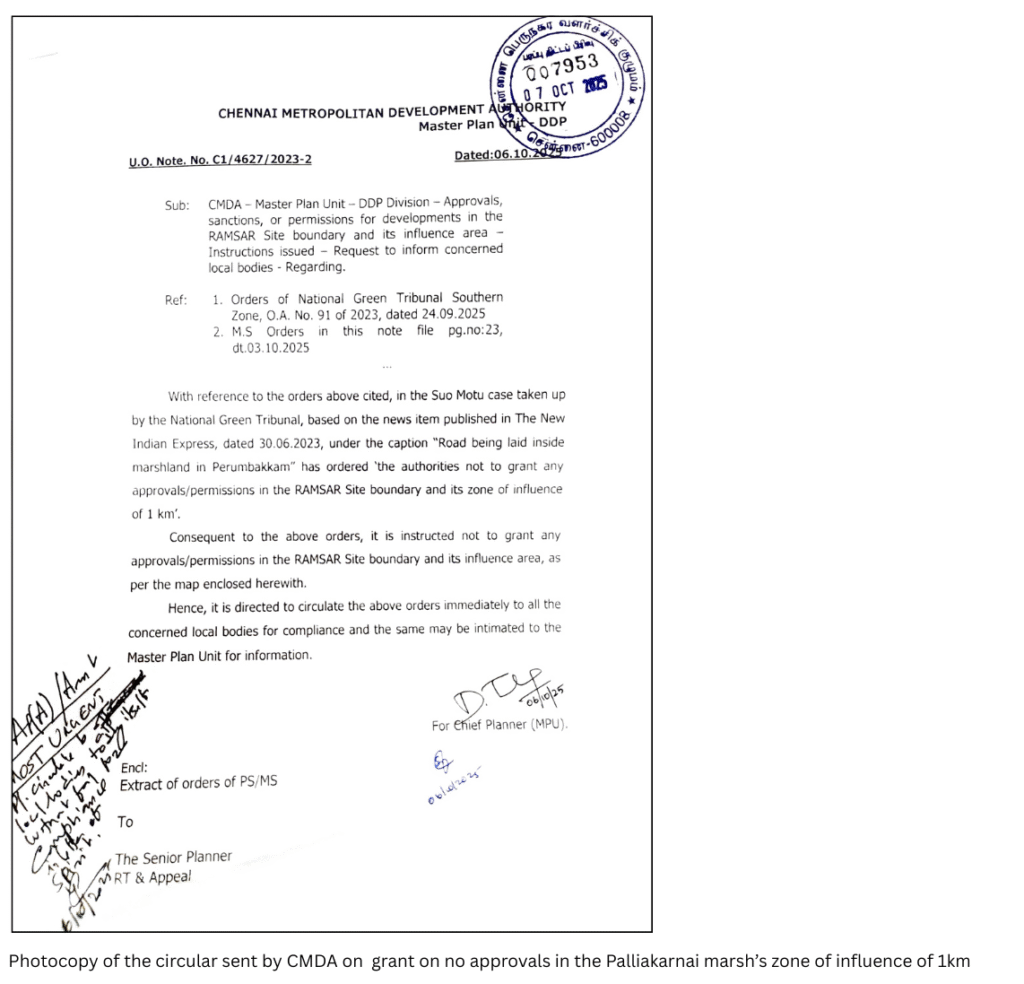
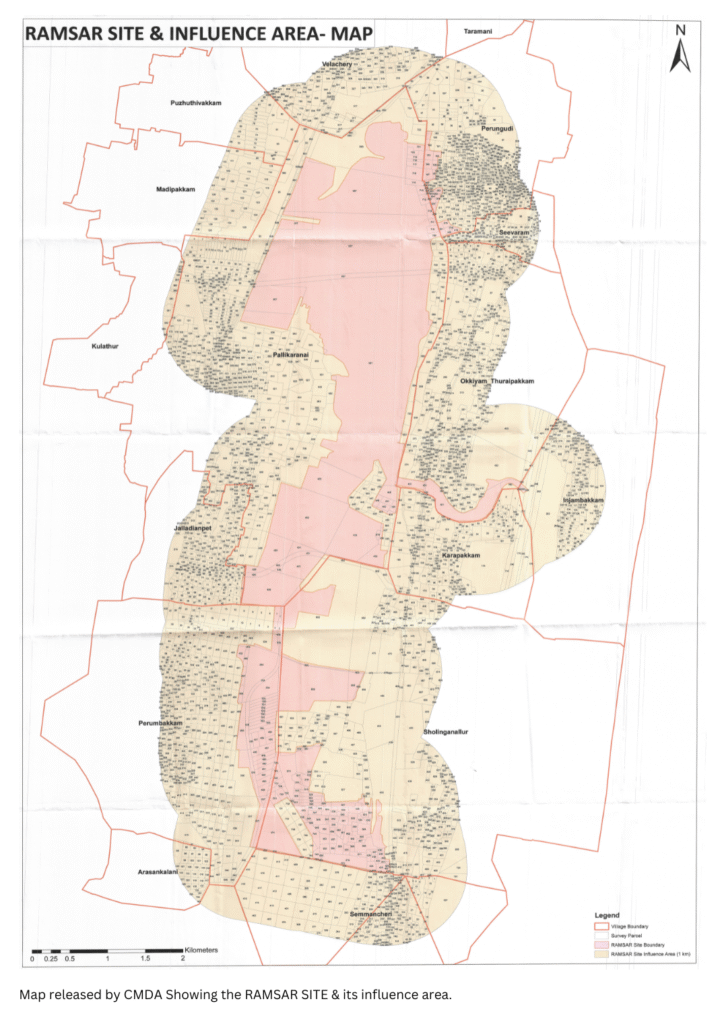
Regulatory Context: CMDA’s No-Development Zone Notification (October 2025).
In October 2025, the Chennai Metropolitan Development Authority (CMDA), following orders of the National Green Tribunal (NGT), issued instructions not to grant approvals or permissions within the RAMSAR Site boundary and its 1 km zone of influence
The official communication clearly states:
“The authorities not to grant any approvals/permissions in the RAMSAR Site boundary and its zone of influence of 1 km.”
This directive applies specifically to the Pallikaranai Ramsar Site and its buffer area.
When the proposed Global Sports Village site is analysed against the notified 1 km buffer map, a portion of the site appears to fall within the designated No-Development Zone (NDZ).
This raises important planning and compliance concerns that require clarification.
Elevation and Vulnerability Mapping
The contour pattern confirms that Pallikaranai Marsh is a shallow, saucer-shaped depression with no significant internal ridges or elevated divides. The average ground elevation ranges between –1 m and +2.5 m above mean sea level.
During the 2015 floods, water levels rose by nearly 2 metres above the marsh bed. Based on this observed behaviour, the 5-metre contour above mean sea level has been mapped to understand the spatial extent of flood vulnerability.
Key Questions That Arise
- If Bhuvan satellite data identifies the site as a water body, how is it classified in planning approvals?
- Has a basin-scale hydrological impact assessment been conducted?
- Does the project comply with the 1 km Ramsar buffer notification as mamdated by the NGT?
- What flood mitigation strategy is proposed, given that the site lies in a drainage convergence zone?
- How will natural runoff from 200+ upstream water bodies be managed?
PROPOSED ALTERNATE SITE: GUINDY RACE COURSE
If the objective is to build a world-class Global Sports Village that is both aspirational and climate-resilient, a more suitable alternative location exists: the Guindy Race Course site.
Why Guindy Race Course?
1. Outside the Pallikaranai Flood Convergence Zone
The Guindy Race Course site, spanning approximately 110 acres, lies upstream of the Pallikaranai river basin boundary. Unlike the Semmanchery site, it does not function as a drainage convergence corridor for the southern Pallikaranai catchment.
This significantly reduces:
- Flood transit vulnerability
- Basin-scale runoff obstruction risk
- Water stagnation potential during extreme monsoon events
Locating the sports facility here would avoid interference with marsh-linked hydrology.
2. Minimal Topographical and Hydrological Disturbance
The site is predominantly flat, requiring limited land grading or filling. This translates into:
- Reduced earthwork
- Lower site preparation cost
- Minimal alteration of natural drainage
- No disturbance to Ramsar-linked wetlands
Unlike low-lying floodplain areas, this location does not require large-scale flood mitigation infrastructure simply to make it buildable.
3. Lower Capital Burden for Site Preparation
Because the terrain is already level and integrated within the urban core, the developer would invest substantially less in:
- Land filling and elevation raising
- Stormwater diversion infrastructure
- Flood protection systems
This improves both economic viability and environmental responsibility.
4. Superior Multi-Modal Connectivity
The Guindy site is one of the best-connected nodes in Chennai:
- Immediate access to Guindy Metro Station
- Direct proximity to Guindy railway station
- Strong bus network and arterial road connectivity
This reduces the need for new transport corridors and ensures seamless access for athletes, spectators, and staff.
Conclusion: Infrastructure, Ecology, and a Responsible Shift in Vision
Tamil Nadu deserves world-class sports infrastructure. Athletes deserve global-standard training facilities. But Chennai also deserves hydrologically responsible planning.
The Global Sports Village is an ambitious and forward-looking initiative. Yet vision must align with ecological reality. Hydrological evidence, stream-order analysis, elevation mapping, and the regulatory context of the Pallikaranai Ramsar buffer indicate that the presently proposed site lies within a vulnerable floodplain and drainage convergence zone. Developing major public infrastructure in such a landscape raises not only environmental concerns but serious safety implications.
This is fundamentally about human safety. As climate change increases the frequency and intensity of extreme rainfall events, low-lying corridors within the Pallikaranai basin are prone to rapid water accumulation. Establishing a large sports complex in this setting may expose communities, staff, spectators, and young athletes to avoidable flood risk.
A responsible shift in vision is therefore essential.
Relocating the Global Sports Village to a hydrologically stable site such as the Guindy Race Course would:
- Preserve the ecological integrity of the Pallikaranai basin
- Avoid placing critical infrastructure within a mapped flood-vulnerable zone
- Reduce long-term climate risk
- Lower construction and mitigation costs
- Strengthen public safety.
Large-scale infrastructure in marsh-connected landscapes must be supported by basin-level hydrological modelling, drainage and flood transit analysis, elevation-based vulnerability assessment, regulatory compliance, and transparent environmental disclosure. Without these safeguards, we risk repeating planning decisions that have historically intensified Chennai’s flood disasters.
A sports village should represent aspiration, resilience, and security — not vulnerability.
Relocation would not weaken the vision; it would strengthen it — making the project climate-resilient, future-ready, and responsibly planned.
A resilient city does not merely build grand infrastructure. It builds in the right place.
Visionary infrastructure must also be safe infrastructure.
Letters to the Sports Minister of Tamil Nadu